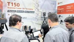
CHINTERGEO 2023 was held in Nanchang, China, from February 14–16, bringing together more than 300 brands across surveying, mapping, and geospatial technologies.
Alongside advances in GNSS, photogrammetry, UAVs, and multi-sensor systems, one trend was especially visible across the exhibition floor: LiDAR was becoming a much more prominent part of the surveying equipment market.
A growing number of established surveying brands and specialist LiDAR companies presented terrestrial and UAV LiDAR systems, reflecting broader adoption of 3D point cloud technology across professional applications.
01 More Diverse and Lightweight LiDAR Systems
Terrestrial laser scanning was one of the most active product categories at the show. Brands including SOUTH Surveying & Mapping, KOLIDA, and LuoJiaYiYun showcased domestically developed terrestrial laser scanners, with compact design and extended range becoming increasingly common product directions.

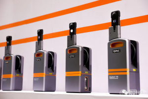
EPiC LiDAR presented terrestrial and UAV LiDAR systems designed for professional 3D data capture.
UAV LiDAR also continued to move toward lighter and more integrated configurations. Hi-Target, GreenValley International, and Geosun Navigation were among the companies demonstrating airborne and multi-platform LiDAR solutions.
The overall direction was clear: smaller, lighter, and more integrated LiDAR systems are making 3D data capture easier to deploy across a wider range of field applications.




03 From Data Capture to Real-World Workflows
The rapid growth of LiDAR hardware also highlighted the next challenge for the industry: turning increasingly large and diverse point clouds into usable project data.

Different platforms and sensor configurations continue to generate different data formats and processing requirements. As LiDAR adoption expands, interoperability, point cloud processing, and smoother integration with downstream professional software will become increasingly important.
CHINTERGEO 2023 showed that LiDAR is moving from a specialist technology toward a more established part of the surveying and geospatial toolkit. The next stage will be defined not only by improvements in range, accuracy, weight, and efficiency, but also by how effectively hardware and software work together in real-world workflows.